Summary of Tropical Storm Ana:
Ana is now the second earliest storm to strike the United States. The first earliest storm was the 1952 Groundhog Day Tropical Storm. The highest wind speed was 60 mph for at least one minute. The was little damage done. The amount of damage was $0. There was one indirect death with Ana. Because of Ana the season has been extended. This season is now from May 8th (The day Ana formed) to, as of right now, November 30th. All need is the name Elsa to be on the list. Just kidding.
Ana is now the second earliest storm to strike the United States. The first earliest storm was the 1952 Groundhog Day Tropical Storm. The highest wind speed was 60 mph for at least one minute. The was little damage done. The amount of damage was $0. There was one indirect death with Ana. Because of Ana the season has been extended. This season is now from May 8th (The day Ana formed) to, as of right now, November 30th. All need is the name Elsa to be on the list. Just kidding.
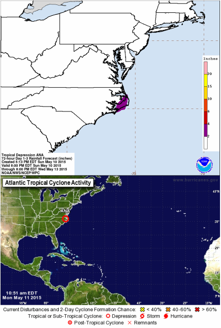
May 11th, 7:19 AM Update: Tropical Depression Ana Over North Carolina
Ana is now over North Carolina. The wind speeds are now at 15 mph. Her minimum central pressure is at 1012 MB. She is moving north-northeast at 4 mph. These updates will continue because of the National Weather Prediction Center. So the pictures that I have been giving with the updates will longer show up. Instead, I know will start include the rainfall forecast with the updates on Ana and on future storms. The NWC does continues to show where the center of Ana is located.
FLOOD WATCHES AND COASTAL FLOOD ADVISORIES ARE IN EFFECT FOR THE CENTRAL PORTION OF COASTAL NORTH CAROLINA
12:25 PM Update: Moving out to the waters
Ana is now moving towards the Atlantic waters. She is moving at a speed of 12 mph with wind speed up to 30 mph. The central minimum pressure has rose to 1014 MB.
No changes to the flood watches and coastal flood advisories.
*Photo courtesy of the National Weather Prediction Center and the National Hurricane Center*
May 10th, 12:21 PM Update: Ana Making Landfall
Hello! Ana is now making landfall at the South Carolina and North Carolina boarder. As she makes her way onto land she will start to lose strength. As of right now she is moving north at 5mph. Wind speeds have dropped to 40mph. The minimum central pressure is now rising to 1004 MB. I hope that the people that are impacted by her are safe right now and hope that Ana won't cause to much damage.
The Tropical Storm Warning south of Little River Inlet South
Carolina to South Santee River South Carolina has been discontinued. The Tropical Storm Warning north of Surf City North Carolina to Cape Lookout North Carolina has been discontinued but:
A Tropical Storm Warning is in effect for...
* Little River Inlet South Carolina to Surf City North Carolina
Now anyone in eastern North Carolina and Virginia should be prepared for any possible impact from Ana.
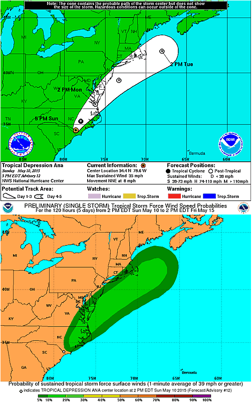
2:15 PM Update: Tropical Storm to Depression
Ana was downgraded to Tropical Depression Ana. She now is nearly stationary in movement. Wind speeds reach up to 35 mph. Her central minimum pressure is now at 1006 MB.
4:53 PM Update:
Ana is still moving inland. This time she is moving north-northeast at 8 mph. Wind speeds still at 35 mph. Central minimum now at 1007 MB. The National Hurricane Center is no longer going to be releasing advisories on Ana. This is the last few steps for Ana folks. The results of her will appear on the website as soon as possible and on here. People who live in the predicted path of Ana, look at the picture of her predicted path, to be ready for rain from the remnants of Ana. All warnings and watches are no longer in effect.
The chance for another storm to form before the season officially starts is unlikely. It could happen but the chance is really low.
*Photos courtesy of the National Hurricane Center*
Hello! Ana is now making landfall at the South Carolina and North Carolina boarder. As she makes her way onto land she will start to lose strength. As of right now she is moving north at 5mph. Wind speeds have dropped to 40mph. The minimum central pressure is now rising to 1004 MB. I hope that the people that are impacted by her are safe right now and hope that Ana won't cause to much damage.
The Tropical Storm Warning south of Little River Inlet South
Carolina to South Santee River South Carolina has been discontinued. The Tropical Storm Warning north of Surf City North Carolina to Cape Lookout North Carolina has been discontinued but:
A Tropical Storm Warning is in effect for...
* Little River Inlet South Carolina to Surf City North Carolina
Now anyone in eastern North Carolina and Virginia should be prepared for any possible impact from Ana.
2:15 PM Update: Tropical Storm to Depression
Ana was downgraded to Tropical Depression Ana. She now is nearly stationary in movement. Wind speeds reach up to 35 mph. Her central minimum pressure is now at 1006 MB.
4:53 PM Update:
Ana is still moving inland. This time she is moving north-northeast at 8 mph. Wind speeds still at 35 mph. Central minimum now at 1007 MB. The National Hurricane Center is no longer going to be releasing advisories on Ana. This is the last few steps for Ana folks. The results of her will appear on the website as soon as possible and on here. People who live in the predicted path of Ana, look at the picture of her predicted path, to be ready for rain from the remnants of Ana. All warnings and watches are no longer in effect.
The chance for another storm to form before the season officially starts is unlikely. It could happen but the chance is really low.
*Photos courtesy of the National Hurricane Center*
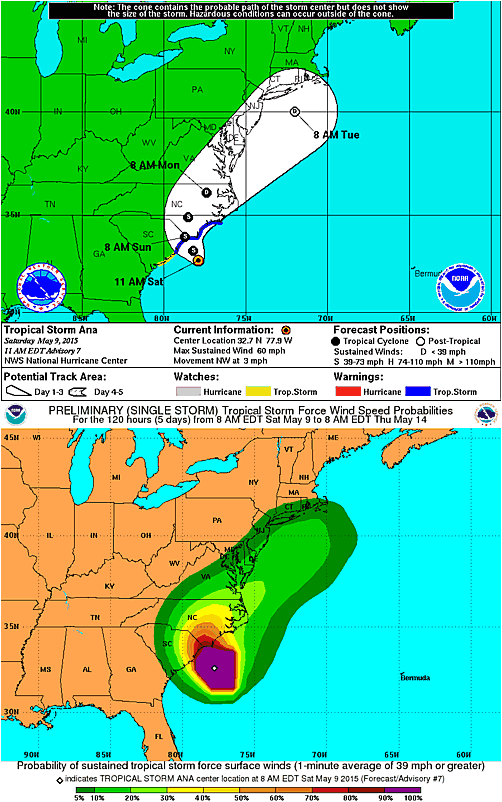
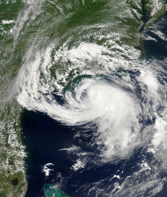
May 9th, 11:05 AM Update: Tropical Storm Ana
Sub-Tropical Storm Ana is now officially Tropical Storm Ana. She is northwest at 3mph. The minimum central pressure is 1001 MB. Maximum wind speeds have reached to 60mph. Again this storm is to be watched carefully by the coast line. We want people to be safe and,if needed, to get out of harm's way quickly and safely.
A Tropical Storm Warning is in effect for...
* South Santee River South Carolina to Cape Lookout
A Tropical Storm Watch is in effect for...
* Edisto Beach South Carolina to South of South Santee River
*Photos courtesy of the National Hurricane Center*
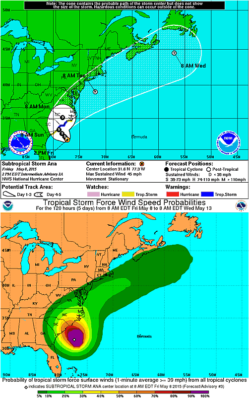
May 8th 2015 7:36 AM, Update: Sub-Tropical Storm Ana
Ana is located 160 miles south-southeast of Myrtle Beach in South Carolina. She is moving north-northwest. Maximum wind speeds are 45mph. The minimum central pressure is at 1004 MB. The United States southeastern coast line better keep an eye on Ana.
A TROPICAL STORM WATCH IS IN EFFECT FOR...
* EDISTO BEACH SOUTH CAROLINA TO CAPE LOOKOUT NORTH CAROLINA
11:43 AM Update:
Ana is now stationary.
A Tropical Storm Warning is in effect for...
* South Santee River to Surf City
A Tropical Storm Watch is in effect for...
* Edisto Beach South Carolina to South of South Santee River
* North of Surf City to Cape Lookout North Carolina
2:38 PM Update:
The minimum central pressure is now at 1001 MB. Ana is still stationary. Wind speeds are still at 45mph.
Watches and Warnings are the same as the 11:43 AM update.
10:00 PM Update:
Everything is still the exact same. There has been a update on the warnings and watches:
A Tropical Storm Warning is in effect for...
* South Santee River South Carolina to Cape Lookout
A Tropical Storm Watch is in effect for...
* Edisto Beach South Carolina to South of South Santee River
*Photos courtesy of National Hurricane Center*
