Updates on Subtropical Storm Alex here.

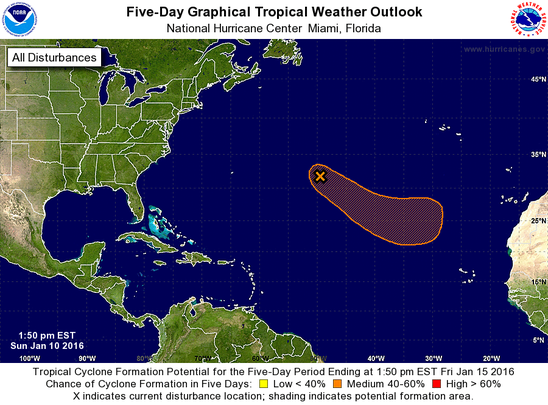
An update on our special system. This system is getting stronger. The chances are now at:
40% chance of development in the next 48 hours and in the next 05 days.
Maybe we will have an extremely early bird er storm this season. Again, the official name list for 2016 hasn't been released and normally wouldn't until spring time.
*Picture courtesy of NHC*
40% chance of development in the next 48 hours and in the next 05 days.
Maybe we will have an extremely early bird er storm this season. Again, the official name list for 2016 hasn't been released and normally wouldn't until spring time.
*Picture courtesy of NHC*
Area 1:
This area is located about 900 miles east of Bermuda. Showers and thunderstorms are active with this system. In the next few days it could receive some sub-tropical or even tropical characteristics in the next few days as this system moves in a direction that rarely happens. The direction it is moving is southeast.
Chance for development in the next 24 hours: 20%
Chance for development in the next 48 days: 40%
*Photo courtesy of the National Hurricane Center*
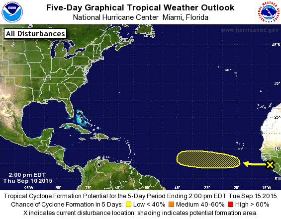
Sep, 10 Update: Area 1
Area 1 is moving west off the coast of Africa at a speed of 15 mph.
Chance of formation in the next 48 hours: 0%
Chance of formation in the next 05 days: 20%
**Photo courtesy of the National Hurricane Center**
Area 1 is moving west off the coast of Africa at a speed of 15 mph.
Chance of formation in the next 48 hours: 0%
Chance of formation in the next 05 days: 20%
**Photo courtesy of the National Hurricane Center**
Grace is no longer here. Full update on her will be up soon.
Updates on Tropical Depression Eight here.
Updates on Tropical Depression Eight here.
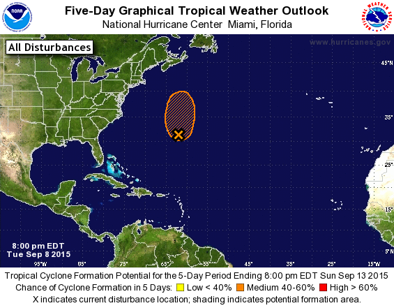
Sep. 8, 9:54 PM Update: Invest 92L
Grace has been downgraded to a depression. Full update here.
Invest 92L
Invest 92L is located 225 miles east-southeast of Bermuda. Conditions are favorable for development for the next couple of days. 92L is expected to remain stationary tonight then move northward tomorrow.
Chance of formation in the next 48 hours and in the next 05 days: 60%
**Photo courtesy of NHC**
Updates on Tropical Storm Grace here. And a summary of Fred will be up shortly.
We not only have Fred currently active but now we have newly formed Tropical Depression 7 active. Updates can be found here.
Invest 91L
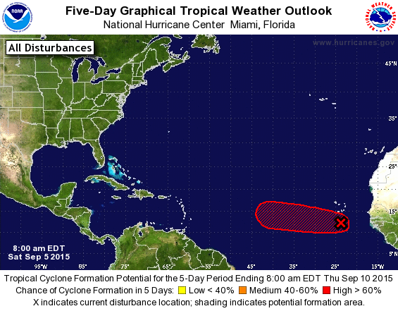
91L is at red now. It is read to become the next system. It is said that if this system does form, it will most likely be a tropical depression. This system is forming 200 miles south of the Cape Verde Islands. Watches and Warnings will be issued if need be.
Chance of formation in the next 48 hours: 80%
Chance of formation in the next 05 days: 90%
**Photo courtesy of the National Hurricane Center**
Updates on Fred here.

Aug. 30, 8:47 AM Update
Remnants of Erika
The remnants of Erika are fighting to stay alive. The chances have dropped since the last update but conditions could become somewhat favorable in the next day or two for re-development.
Chance of re-formation in the next 48 hours: 20%
Chance of re-formation in the next 05 days: 30%
Also we now have updates on newly formed Tropical Storm Fred here.
**Photo courtesy of the National Hurricane Center**
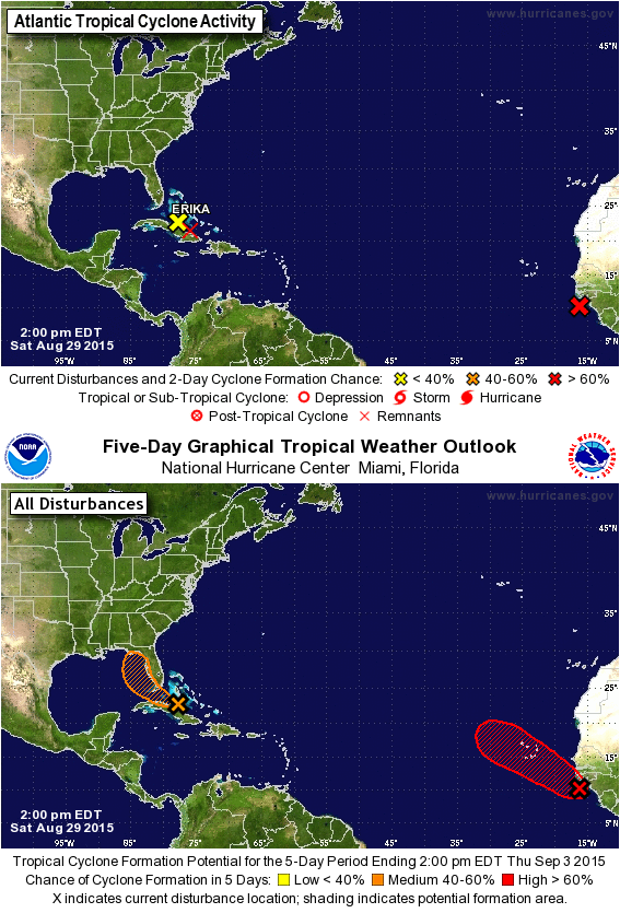
Aug. 29, 2:45 PM Update: Remnants of Erika and Invest 99L
Special Alert for former Tropical Storm Erika here.
Invest 99L
We most certainly got another system ready to be born. Cape Verde Islands better keep an eye on this as this area is expected to move northwestward towards the Cape Verde Islands.
Chance of formation in the next 48 hours: 70%
Chance of formation in the next 05 days: 90%
**Photos courtesy of the National Hurricane Center**
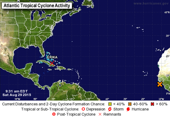
Aug. 29th, 9:29 AM Update: Area 1
This area is getting stronger folks. Could we have another storm on the path to birth? We shall see.
Chance of formation in the next 48 hours: 50%
Chance of formation in the next 05 days: 70%
Last Update on Erika here.
**Photo courtesy of NHC**
This area is getting stronger folks. Could we have another storm on the path to birth? We shall see.
Chance of formation in the next 48 hours: 50%
Chance of formation in the next 05 days: 70%
Last Update on Erika here.
**Photo courtesy of NHC**
Updates on Erika as she makes landfall on many Islands here.
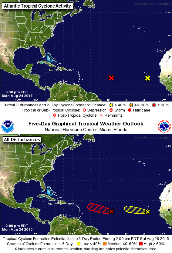
Aug. 24, 7:17 PM Update: Danny, Invest 98L and Area 2
Danny died out today. All warnings and watches have been dropped. A summary of the storm will be posted to the website in a few days.
Invest 98L
All you need to know is that it is ready to be named.
Chance of formation in the next 48 hours and in the next 05 days: 90%
Area 2 ( Yellow 'X')
This area is just dying.
Chance of formation in the next 48 hours: 0%
Chance of formation in the next 05 days: 10%
**Photos courtesy of NHC**
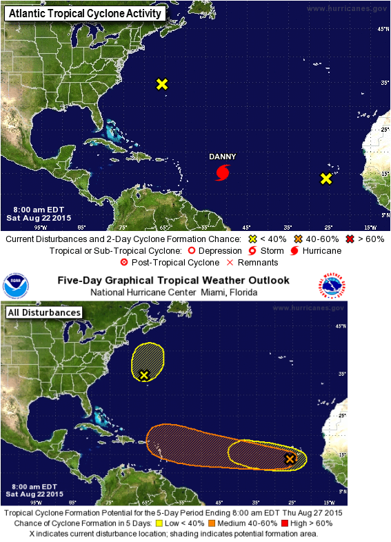
Aug. 22, 10:25 AM Update:
Update on Danny here.
Invest 97L
97 is starting weaken. It could produce a Tropical Depression before hitting unfavorable conditions.
Chance of formation in the next 48 hours: 20%
Chance of formation in the next 05 days: 30%
Area 2
Area 2 is getting stronger. As it moves westward over the Atlantic, it could develop into something.
Chance of formation in the next 48 hours: 30%
Chance of formation in the next 05 days: 60%
Area 3
Not much has changed. The chances did change a little.
Chance of formation in the next 48 hours: 10%
Chance of formation in the next 05 days: 30%
**Photos courtesy of NHC**
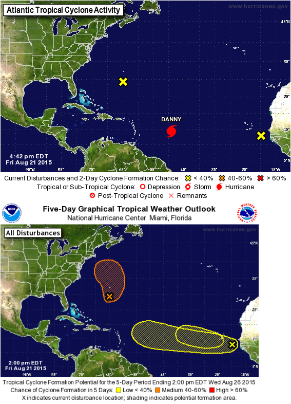
Aug. 21, 5:25 PM Update: Invest 97L, Ivest 98L?? and Invest 99L?? (To see a full update on these areas go to the Facebook page by clicking here.
Update on Danny here.
Okay so first off, a mistake was made so I would like to apologize right off the bat. In the last few updates, I said there was Invest 98L, the area that was leaving the coast of Africa. It turns out that that area isn't officially classified as Invest 98L. So again I apologize for the mistake in the last few updates.
Invest 97L ( Yellow 'X' on the left of Danny in two day outlook, Orange 'X' and orange area in five day outlook )
Chance of formation in the next 48 hours: 20%
Chance of formation in the next 05 days: 50%
Invest 98L?? ( Yellow 'X' to the right of Danny in the two day outlook, Yellow 'X' with the longer yellow area in the five day outlook)
Chance of formation in the next 48 hours: 10%
Chance of formation in the next 05 days: 30%
Invest 99L??( Smaller yellow area under the bigger yellow area on the five day outlook)
Chance of formation in the next 48 hours: 0%
Chance of formation in the next 05 days: 20%
**Photos courtesy of the National Hurricane Center**
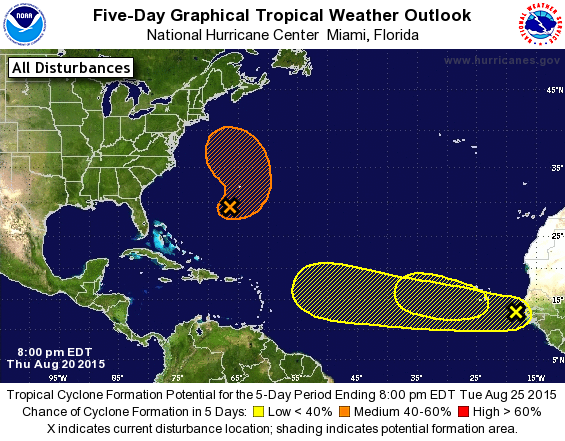
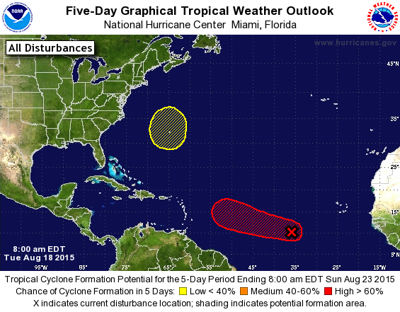
Aug. 20, 8:24 PM Update: Invest areas 97L, 98L and 99L??
Invest area 97L still has the same percent chances as before. But the area of formation got bigger in the five day outlook.
Invest 98L got a new shaded area as well as new chance numbers.
Chance of formation in the next 48 hours: 10%
Chance of formation in the next 05 days: 30%
A new area has popped up on the five day outlook but not yet on the two day outlook. NHC says that it might has a small chance of forming anything early next week. Could it become Invest 99L?
Chance of formation in the next 48 hours: 0%
Chance of formation in the next 05 days: 20%
**Photo courtesy of NHC**
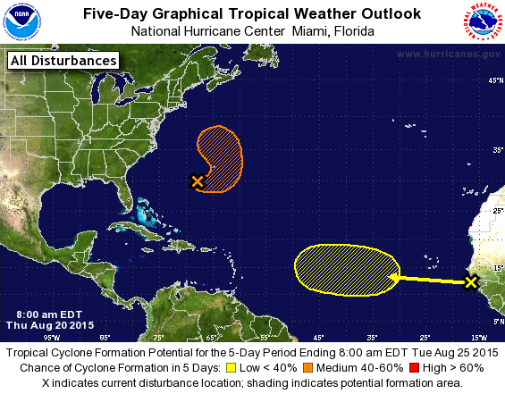
Aug. 20, 11:33 AM Update: Invest 97L and Invest 98L
Danny is now a Hurricane. Update here.
Invest 97L (Yellow 'X' near Bermuda and the orange area on the 5 day outlook)
Invest 97L is finally happening. This area is expected to form at least a depression over the weekend.
Chance of formation in the next 48 hours: 20%
Chance of formation in the next 05 days: 60%
Invest 98L (Yellow 'X' just leaving Africa)
This area is going to be fun to watch. This area is expect to get stronger in the yellow shaded area on the 5 day outlook. It would be kinda interesting to see if it not only forms something but to see how close it follows Danny's path.
Chance of formation in the next 48 hours: 0%
Chance of formation in the next 05 days: 20%
**Photo Courtesy of the National Hurricane Center**
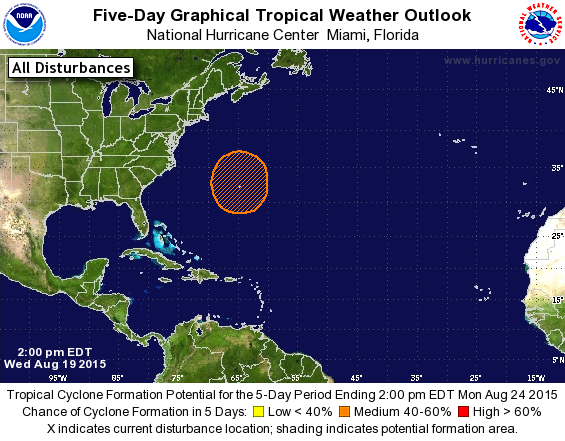
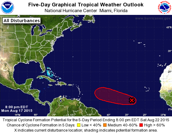
Aug. 19, 5:51 PM Update: Invest 97L?!
The area that is forecast to form in the next few days just got an update so here it is.
Chance of formation in the next 48 hours: 0%
Chance of formation in the next 05 days: 40%
**Photo courtesy of NHC**
Updates on Danny here.
The area that is forecast to form in the next few days just got an update so here it is.
Chance of formation in the next 48 hours: 0%
Chance of formation in the next 05 days: 40%
**Photo courtesy of NHC**
Updates on Danny here.
We have Tropical Depression 4 active right now. Click here to visit the page with updates on it.
Also we have a area in the five day track that popped up around Bermuda.
Chance of formation in the next 48 hours: 0%.
Chance of formation in the next 05 days: 20%
**Photo Courtesy of the National Hurricane Center**
Also we have a area in the five day track that popped up around Bermuda.
Chance of formation in the next 48 hours: 0%.
Chance of formation in the next 05 days: 20%
**Photo Courtesy of the National Hurricane Center**
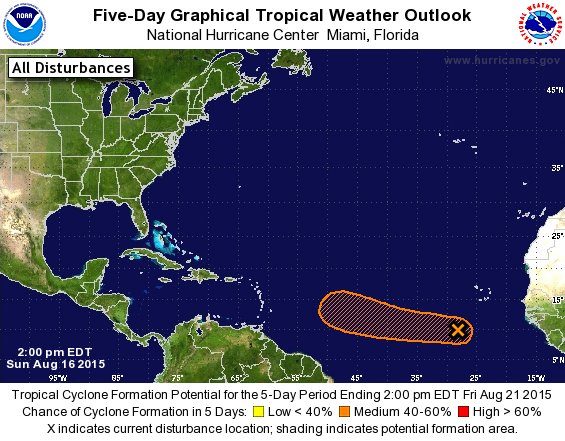
Aug. 17th, 9:41 PM Update: Invest 96L
This area is ready to become a storm now!! Most likely Tropical Depression 4 for right now in the next few days. Invest 96L is moving west-northwest at a speed between 10-15 mph.
Chance of formation in the next 48 hours: 60%
Chance of formation in the next 05 days: 80%
**Photo courtesy of NHC**
This area is ready to become a storm now!! Most likely Tropical Depression 4 for right now in the next few days. Invest 96L is moving west-northwest at a speed between 10-15 mph.
Chance of formation in the next 48 hours: 60%
Chance of formation in the next 05 days: 80%
**Photo courtesy of NHC**
Aug 16th, 4:03 PM Update: Invest 96L
Hello!!
We have invest 96L right now everyone! It is located several hundred miles southwest of the Cape Verde Islands. This system is expect to at least produce Tropical Depression 4 by mid week as it head west at 15 mph.
Chance of formation in the next 48 hours: 50%
Chance of formation in the next 05 days: 60%
**Picture courtesy of NHC**
This is the month when, in a normal active season, the season kicks up. Doubt it will kick up that much. If anything, we could see more areas and maybe 2-4 more storms before the season ends.
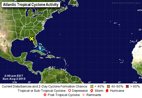
Aug 2, 7:05 PM Update:
There is a new area of interest. It is located over Florida right now. Conditions are not expect to become favorable for formation.
Chance of formation in the next 48 hours and in the next 05 days: 10%
*Photo courtesy of NHC*
There is a new area of interest. It is located over Florida right now. Conditions are not expect to become favorable for formation.
Chance of formation in the next 48 hours and in the next 05 days: 10%
*Photo courtesy of NHC*
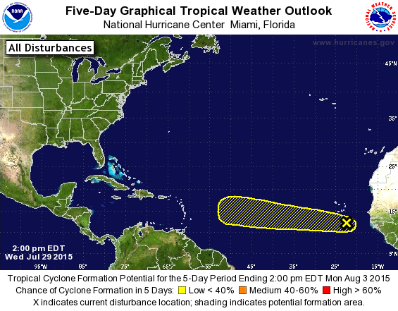
July 29, 1:37 PM Update: Invest 94L
There is a new investigation area. Invest 94L.
It is a couple hundred miles south-southeast of the Cape Verde Islands. It is moving westward at a speed of 15 mph. Conditions are predicted to be somewhat favorable for slow development though out the weekend.
Chance of formation in the next 48 hours: 10%
Chance of formation in the next 05 days: 30%
*Photo courtesy of NHC*
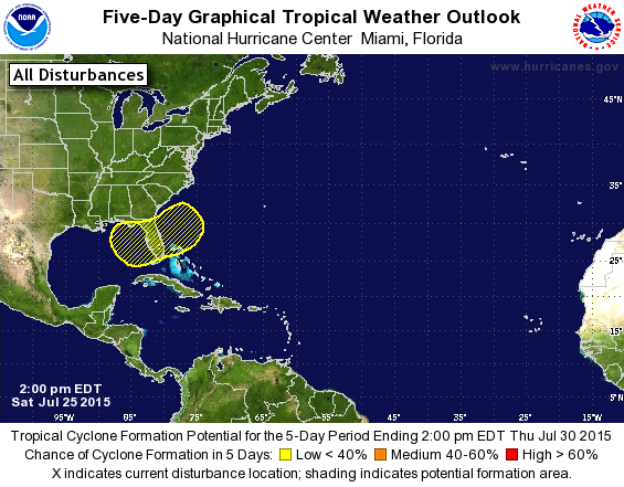
July 25th, 3:35 PM Update:
That area was moved to be over Florida.
Chance of formation in the next 48 hours: 0%
Chance of formation in the next 05 days: 10%
*Photo courtesy of the National Hurricane Center*
That area was moved to be over Florida.
Chance of formation in the next 48 hours: 0%
Chance of formation in the next 05 days: 10%
*Photo courtesy of the National Hurricane Center*
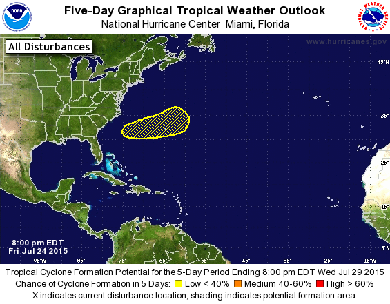
July 24th, 9:07 PM Update:
Okay so all that talk about an area forming that could produce something isn't all that far fetched. The National Hurricane Center is predicting an area to form something anywhere between the southeast coast of the United States and Bermuda.
Chance of formation in the next 48 hours: 0%
Chance of formation in the next 05 days: 20%
*Photo courtesy of the National Hurricane Center*
Just a few days ago Claudette died. And now we have something else.
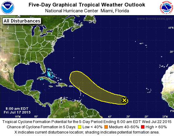
July 17th, 9:29 AM Update: Invest 93L
Invest 93L is located more than 1000 miles west-southwest of the Cape Verde Islands. Conditions will be somewhat favorable for the next couple a days then won't be after that.
Chance of formation in the next 48 hours: 10%
Chance of formation in the next 5 days: 20%
Photo Courtesy of NHC
July 13th, 12:43 PM Update: Tropical Storm Claudette
Invest 92L is now known at Tropical Storm Claudette. Information has yet to be fully released. She is going to move northeast still so she is still no threat to land. Because of this very little will be posted about her as she is not a threat to land.
Invest 92L is now known at Tropical Storm Claudette. Information has yet to be fully released. She is going to move northeast still so she is still no threat to land. Because of this very little will be posted about her as she is not a threat to land.
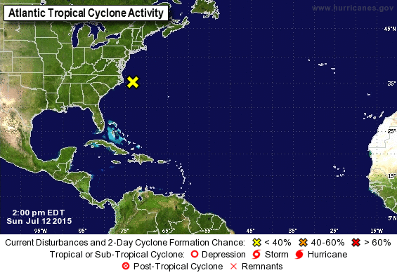
July 12th
The area of interest is off the coast of North Carolina. The conditions are marginally conductive for a sub-tropical or a tropical storm in the next few days. It is moving northeast away from the United States. So it is really not a threat to land. However rip currents could happen based on the fact that rip currents seem to happen with every storm that happens.
Chance of formation in the next 48 hours and 5 days are at 20%
*Photo courtesy of NHC*
June 6th, 3:04pm Update:
There is a disturbance out in the Gulf of Mexico. It is headed towards Texas. The maximum winds were reaching up to 45 mph.
Chances of formation is at 90% chance for both in the next 48hrs and in the next 5 days. If it doesn't form into anything before it hits Texas, the middle and upper Texas coast and in the extreme southwestern part of Louisiana will have tropical storm like conditions as heavy rainfall with happen later today and Tuesday. There are risks of flooding with the disturbance for the eastern part of Texas and western part of Louisiana. More information will be added to this post as it gets released.
Sub-Topical Storm Ana is now Tropical Storm Ana. Click here to see the current and updated information on her.
To find information on Sub-Tropical Storm Ana, go to the 2015 season and click on the sub page for her.
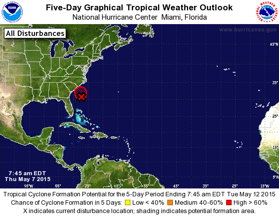
May 7th 2015, 10:13pm Update: Sub-Tropical Storm Ana
It is now confirmed that this disturbance is now a Sub-Tropical Storm. Sub-Tropical Storm Ana. NHC will start the information at 11. so tomorrow I will post on the website the information in the morning.
What is a Sub-Tropical Storm you may ask? Well it is, in a nutshell, a storm that the central convection is fairly near the center and a warming core in the mid-levels of the troposphere.
May 7th 2015, 8:40am Update:
This disturbance is getting stronger folks! It is headed towards the coast line of North and South Carolina. So if you live down there, KEEP AN EYE ON THIS SYSTEM!!! It could be upgraded today to either to Tropical Depression One or Tropical Storm Ana. The National Hurricane Center is sending an Air Force Aircraft to investigate this system and see if should be upgraded now.
70% chance (High) of forming in the next 48 hours and in the next 5 days.
8:23pm Update:
This disturbance is just taking it's time. It's in no hurry. After all the official season hasn't started yet. This disturbance is now just east of South Carolina's coast. It is south-southeast of the North Carolina and South Carolina boarder. It is producing wind speeds up to 40-45 mph north and west of the center.
90% chance (HIGH) of forming in the next 48 hours and in the next 5 days.
This is about to become a Tropical Depression or jump right to Tropical Storm status. If it does become a Tropical Storm, it will not only be the first named storm (Ana) but it will be the early bird, as previously mentioned, as the season is to start in 24 days. The east-northeastern coast line should really keep an eye on this system. It is expected to turn north-northwest a little bit.
*Photo courtesy of the National Hurricane Center*

May 6th 2015, 9:18pm Update:
The disturbance is strengthening!! It is moving northward right now. The southeastern coast should keep an eye on this system. This is could become a subtropical storm or a tropical storm by tomorrow or Friday. Yes you read right folks! We may have an early bird!
60% chance (Medium) of forming in the next 48 hours
60% chance (Medium) of forming in the next 5 days
*Picture courtesy of the National Hurricane Center*

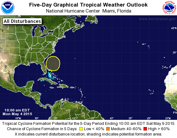
May 5th 2015, Update:
The predicted disturbance is now officially a disturbance! It is located extends from the Bahamas, Cuba, and southern Florida. It is moving northward. It is expected to reach at least subtropical status. We shall see what happens. If it forms into a depression, we will have the first storm of the season before the season starts.
20% chance (Low) of forming in the next 48 hours
40% chance (Medium) of forming in the next 5 days.
*Picture courtesy of the National Hurricane Center*
May 4th 2015, Update:
There is a disturbance prediction just northwest of the Bahamas ladies and gentlemen! Yes I know that the Atlantic Hurricane season doesn't start till June 1st but this can happen. Where a storm forms early. It's rare though. This system hasn't developed yet. This prediction is from the 5 day prediction from NOAA NWS National Hurricane Center. This "disturbance" is at a rating of low for formation.
0% chance (Low) of forming in the next 48 hours
30% chance (Low) of forming in the next 5 days.
*Picture courtesy of the National Hurricane Center*
The name "ISIS" was removed from the hurricane name list. Not because it was a strong and devastating storm but because of what has been happening in the middle east. The reason it was first put on the list and was used six times before being removed was because the Egyptian goddess Isis.
The name Odile was taken down by request from Mexico. Odile cause major devastation to the Baja California peninsula. It left tourists stranded for days.
All this was found from Fox California. http://www.foxcarolina.com/…/isis-removed-from-list-of-hurr…
The name Odile was taken down by request from Mexico. Odile cause major devastation to the Baja California peninsula. It left tourists stranded for days.
All this was found from Fox California. http://www.foxcarolina.com/…/isis-removed-from-list-of-hurr…
|
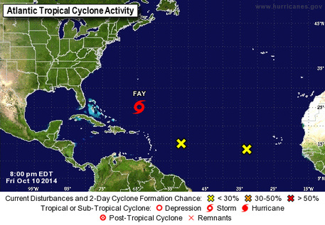
Oct. 10, 2014 Updates: Fay and Areas 1 and 2
Looks like the Atlantic is trying to become active again and it is working. Fay: Fay is a subtropical storm out in the Atlantic. Not a threat to the United States. She has winds of up to 50 knots ( 60 mph ) and is moving north-north west at 10 knots ( 12 mph ). A TROPICAL STORM WATCH IS IN EFFECT FOR... * BERMUDA Area 1: This is system is moving west-northwest at 10 mph. If it is strong enough, this system could be a Tropical Depression and then we would have two storms active. Chance of formation in the next 48 hrs: 20% Chance of formation in the next 5 days: 60% Area 2: This system is not expected to do much. Chance of formation for the next 48hrs and 5 days is at 10% *picture courtesy of NCH* |
|
|
October 5 2014
As this season is starting to end, we look to next year and wonder what will happen. What do you think next year will be like? |
|
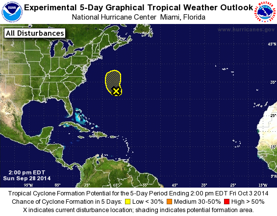
September 28 2014
Not much is expected out of this disturbance. Conditions are going to be unfavorable as the week starts. 10% chance of forming in the next 48 hrs and in the next five days *Picture courtesy of National Hurricane Center* |
September 17 2014
Hurricane Edouard page is finally up!!!! Sorry for how late it is.
Hurricane Edouard page is finally up!!!! Sorry for how late it is.
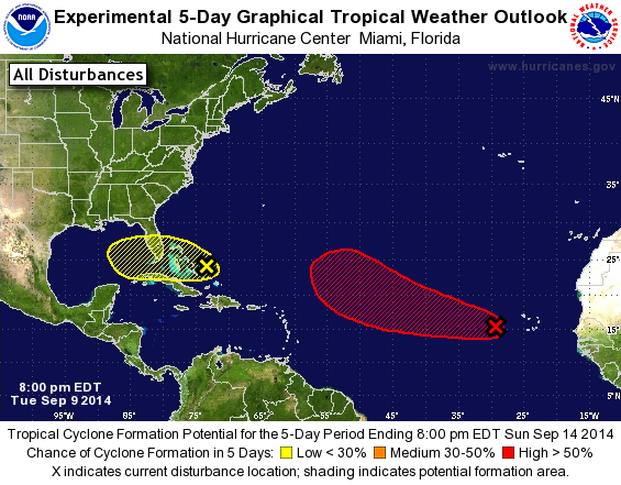
September 9 2014
We have two areas that are being watched by NHC.
Area 1 ( Red ): This area has been watch by NHC and other tropical weather watcher like AHW since Sep. 5 ( See below ). Chances of formation in the the next 48hrs is at 20% and a 70% in the next five days.
Area 2 ( Yellow ): This is a new area that popped up today. Located over the Bahamas, it is moving west at about 10 mph. Chance of formation in the next 48hrs is at 10% and a 20% chance in the next five days.
* Photo courtesy of NHC *
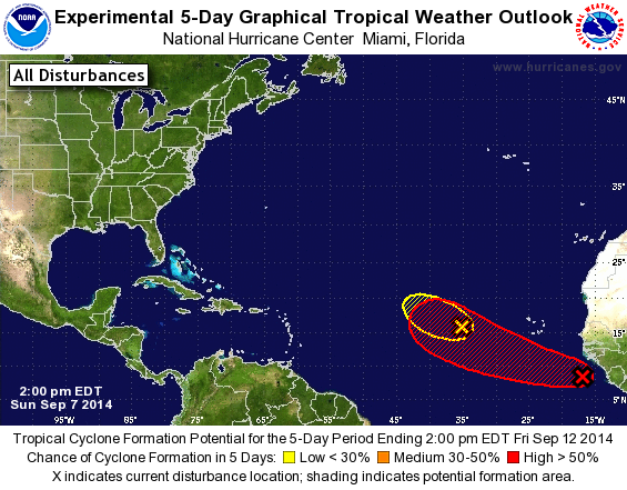
September 7 2014
We have two area this evening that are being watched by NHC.
Area 1 ( Red ): Located off the coast of Africa, it is moving westward as of right now and might change direction to west-northwest as the days continue. It could form any day now. Chances of it forming in the next 48hrs is 30% and a 60% of forming in the next five days.
Area 2 ( Yellow ): Located 657 miles west of the Cape Verde Islands. This system is fighting to stay alive but conditions aren't favorable for formation and doesn't look like it could change. Chance of formation for both the next 48 hrs and in the next five days is at 10%.
*Picture courtesy of NHC*
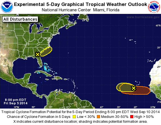
September 5 2014
We have three areas tonight that are highlighted by NHC.
Area 1 ( Yellow ): Located over Georgia and Florida, it is expected to move northeastward towards the coastlines of South Carolina, North Carolina, and Georgia. Little development is expected as days go on. Chance of formation in the next 48hrs is 10% and 20% in the next five days.
Area 2 ( Yellow) : Moving over the Atlantic at 15 mph. Development is unlikely due to the dry arimass. Chance of formation in the next 48hrs and in the next five days is at 10%.
Area 3 ( Orange ): A tropical wave is expected to form off the coast of Africa and move out over the Atlantic. Conditions will be a bit more favorable by the time this happens. Chance of formation in the next 48hrs is at 0% and 30% in the next five days.
*Picture courtesy of NHC*
